
Weather conditions today and Monday are forecast to support extreme fire activity with “significant growth,” building off aggressive fire behaviour on Friday and Saturday, says NWT Fire.
Residents of Kakisa, Wrigley, Deline, are watching wildfire activity a couple of dozen kilometres away, but are not at threat at present, read a release Sunday afternoon.
However, proactive structure protection crews are in the communities and the outlying areas, setting up sprinklers and other measures.
The entire territory is blanketed in smoke being blown from southern wildfires and those inside our border.
The most serious situation appears to be in the South Slave region, with fire SS048, 34 kilometres west of Kakisa on west side of Kakisa Lake, and 40 kilometres south of Fort Providence.
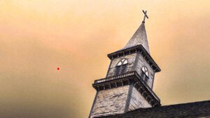
Eerie smoke-filled sky over a church in Fort Providence on Friday evening. Red dot is the sun. (James O’Connor/CKLB)
Crews are working to set up sprinklers on cabins, highway, fibre lines, and other values at risk in the area. The community is not currently at risk.
Amy Kennedy is a wildfire information officer with the territorial government.
“The conditions forecast are likely to render direct attack impossible,” she stated.
“Crews are focused on community protection efforts and setting up sprinklers around critical infrastructure. Resources have been shifted from other priorities to this wildfire to assist in the effort.”
In the Dehcho region, fire FS010 is located 20 kilometres south of Wrigley on the west side of Mackenzie River.
“Proactive structure protection unit trailers have been sent to Wrigley and are setting up sprinklers/structure protection on critical infrastructure and along the river,” stated Kennedy, noting there will be heavy smoke on Highway 1 and in the community.
In the Sahtu region, fire VQ10 is 35 kilometres south and west of Deline and 35 kilometres south and east of Tulita.
The two communities are not currently at risk, stated Kennedy.
“However, with the potential for extreme fire conditions over the next 48 hours, there are proactive efforts being prepared to protect the community in the case fire does approach in the future,” she stated.
A structure protection team will work with the community.
In the North Slave region, fire ZF019 is 24 kilometres west of Wekweeti. Crews are monitoring the fire for potential spotting over snare lake and will assess when visibility improves.
There are fire bans in place in most areas in southern NWT, please check with your community on the NWT Fire web page.
NWT Fire asks boaters and campers to put out any campfires, as last weekend, some smouldering campfires were found along banks of rivers and lakes.
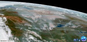
Satellite image from late Friday night of all the fires over the NWT. (Photo courtesy McCall Weather/Facebook)


